LULC Transformation in Kutupalong Refugee Camp (2017–2024)
- Software ArcMap
- Timeframe 2017-2024
- Data Sentinel 2
- Study Area Kutupalong Camp
This series illustrates land use and land cover (LULC) shifts across three key years—2017, 2020, and 2024—highlighting dramatic environmental changes in response to Rohingya settlement. Between 2017 and 2024, built-up areas surged from 7.75 km² to 17.31 km², while tree cover plummeted from 7.26 km² to just 0.016 km², indicating large-scale deforestation—trends confirmed by satellite-based studies showing up to 74% forest loss from 2015–2021 and over 3,200 ha cleared by 2024.
What It Shows:
- Mapping the Transformation: Land Cover Change in Kutupalong Refugee Camp (2017–2024)

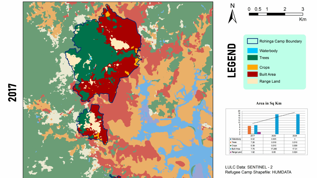
For high quality image visit this link🖼️ Map 1: 2017 LULC Baseline
Description: The map reveals a relatively modest built-up footprint (7.75 km²) and robust tree cover (7.26 km²), set against 1.92 km² of rangeland and small waterbodies. This pre-expansion snapshot reflects early stages following the 2017 refugee influx, with natural forest still dominant and human infrastructure beginning to take hold.
📍 Qualitative Insight: The area had yet to experience significant land clearance—UN data indicates ~1,219–1,313 ha were cleared by early 2018.

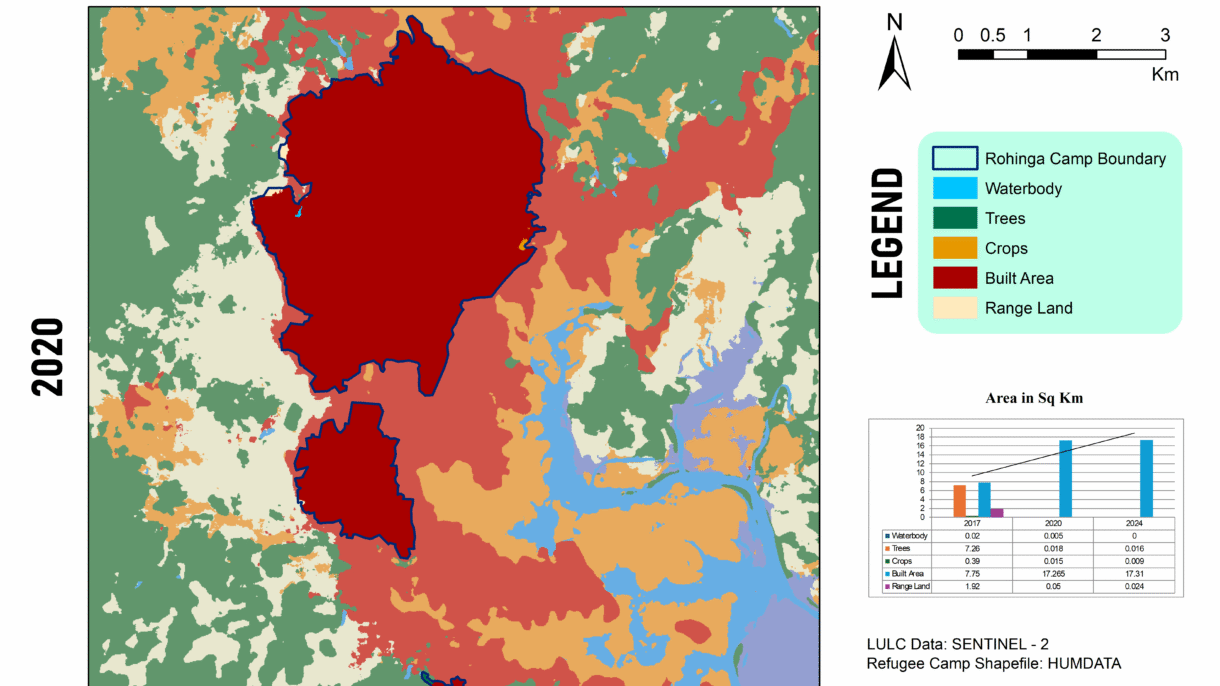
For high quality image visit this link🖼️ Map 2: 2020 LULC – Peak Transformation
Description: By 2020, built-up area had more than doubled (17.27 km²) while tree and crop cover collapsed to near-zero levels. Waterbodies shrank to only 0.005 km², rangeland nearly vanishing (0.05 km²).
📍 Quantitative Insight: In just three years, settlements expanded roughly tenfold, echoing reports of ~71% forest loss from 2015–2018 and dramatic wetland increases, though only until 2018, matching observed exponential LULC shifts.

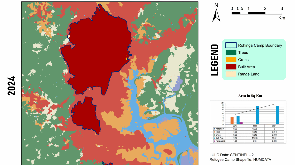
For high quality image visit this link🖼️ Map 3: 2024 LULC – Stabilization or Continuing Loss?
Description: The latest map shows built-up area plateauing (~17.31 km²), but vegetation remains decimated (trees: 0.016 km²; crops: 0.009 km²), and open rangeland is minimal (0.024 km²). Waterbodies are effectively gone.
📍 Contextual Insight: This aligns with findings of ~3,200 ha of forest clearance by 2024 and ongoing rehabilitation efforts on degraded lands, though full ecological recovery has yet to materialize.
📊 Integrating My Data (2017–2024)
| Year | Waterbodies | Trees | Crops | Built-up | Rangeland |
|---|---|---|---|---|---|
| 2017 | 0.02 km² | 7.26 km² | 0.39 km² | 7.75 km² | 1.92 km² |
| 2020 | 0.005 km² | 0.018 km² | 0.015 km² | 17.27 km² | 0.05 km² |
| 2024 | 0 km² | 0.016 km² | 0.009 km² | 17.31 km² | 0.024 km² |
These figures demonstrate dramatic deforestation and urban expansion up to 2020, with built-up area stabilizing thereafter—likely due to space saturation—while natural land cover remains critically low.
Between 2017 and 2024, the rapid influx of Rohingya refugees into Cox’s Bazar has devastated the region’s natural environment. Approximately 8,000 acres of forest—around 6,164 acres inside camp boundaries and another 1,837 acres around—were cleared, primarily for shelter construction and firewood rsisinternational.org+7pmc.ncbi.nlm.nih.gov+7aljazeera.com+7rsisinternational.org+2en.wikipedia.org+2undrr.org+2. This large-scale deforestation extended over 26,600 hectares of forest in surrounding Ukhia, Whykong, and Teknaf ranges, impacting critical biodiversity zones like Teknaf Wildlife Sanctuary, Inani, and Himchhari National Parks, and pushing wildlife, including endangered Asian elephants, into closer and often dangerous proximity with humans. Removal of vegetation and hill cutting—50% of which was observed in some spots—has severely destabilized slopes, triggering widespread soil erosion, frequent landslides, flash floods, and even hill collapses during the monsoon reddit.com. The disappearance of groundcover further increased surface heat and disrupted natural water retention, leading to rising land surface temperatures (~+7–8 °C) and reduced groundwater levels due to excessive tube-well use reddit.com+10mdpi.com+10icccad.net+10. This has led to a cascade of adverse effects: habitat fragmentation, human–wildlife conflicts, heightened flood risk, pollution of water sources, and loss of ecosystem services, including biodiversity, carbon storage, and soil fertility rsisinternational.org. While some mitigation efforts—such as vetiver grass planting and reforestation programs by IOM, FAO, and UN agencies—have begun to stabilize slopes and reduce landslide incidents, the scale of ecological damage remains vast and long-term resilience demands sustained restoration and strategic land-use planning iom.int+1undrr.org+1.
Need Help?
If you’re interested in replicating this project or need guidance for your region, feel free to reach out! I’m happy to share workflows, data sources, or troubleshoot GIS challenges. Let’s collaborate to build resilient communities. 🌍✨
Email: official.parvej.hossain@gmail.com